|
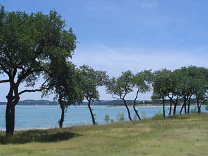 |
Photo
of Canyon Lake |
CANYON LAKE, TEXAS. Water impoundment began in 1964 and the conservation
pool level was reached in 1968. Canyon Lake, formerly known as Canyon Reservoir,
is on the Guadalupe River twelve miles northwest of New Braunfels in northern
Comal County (at 29°52' N, 98°12' W). The project is owned by the
United States government and operated by the United States Army Corps of
Engineers, Fort Worth District. The local cooperative agency is the Guadalupe-Blanco
River Authority,qv which, for paying part of the cost, has rights to the
conservation storage space and control over the use and release of conservation
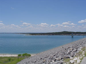
water. The lake, formed by a rolled earthfill dam 6,830 feet long, is used
for flood control, water conservation, and recreation. Construction of the
dam was started on June 27, 1958, and impoundment of water began on June
16, 1964. The general contractor was Tecon Corporation of Dallas. The crest
of the spillway is 943 feet above mean sea level, and the conservation storage
capacity is 382,000 acre-feet with a surface area of 8,240 acres and a sixty-mile
shoreline at 909 feet above mean sea level. Stored water is used for municipal,
industrial, and irrigation purposes and for the development of hydroelectric
power downstream. The drainage area above the dam is 1,432 square miles.
 |
|
Photo
of the Canyon Lake Dam |
The construction of the dam and subsequent growth of the area surrounding
the lake are among the most significant developments in twentieth-century
Comal County history. Inundating a portion of the Guadalupe River valley
cost the area productive farm and ranch land as well as two rural communities-Cranes
Mill and Hancock-but it also stimulated development that transformed the
economy and demography of the county. After the lake was filled north central
Comal County became one of the largest population centers in Central Texas
and the focus of a resort and tourist industry that rivaled manufacturing
and agriculture in importance to the county economy. The dam made possible
land development along the lake shore and in the area downstream, which
for the first time was protected from periodic flooding. Even as the lake
was filling, the first residential subdivisions-including Canyon Lake Hills
and Canyon Lake Village-began attracting permanent and temporary residents.
By 1967 there were forty-six subdivisions on the shores of Canyon Lake and
fourteen more in the hills surrounding it. By the mid-1980s more than eighty
neighborhoods had been built, and estimates of the permanent population
of the lake area ranged from 12,000 to 15,000. Seven lakeside public parks
and two public marinas served thousands of weekend visitors. Residents and
tourists supported a variety of new businesses and service industries that
transformed the former farm and ranch communities of Sattler and Startzville
into thriving commercial centers and occasioned the new town of Canyon City.
In the late 1980s two schools and thirteen churches served the permanent
residents of the lake area. The Canyon Lake community, forty-eight miles
from San Antonio and fifty-six from Austin, continued to attract new commuter,
retired, and weekend residents.
CRANES MILL, TEXAS. Cranes Mill, a stock-raising community seventeen
miles northwest of New Braunfels in central Comal County, was named for
J. B. Crain, who built a mill at the Gum Spring crossing on the Guadalupe
River in the early 1850s. The spelling became Crane when a post office
was established there before the Civil War.qv Postal service to Cranes
Mill may have been interrupted just after the war, but by 1872 August
Engel, a minister, teacher, and storeowner, ran the community's post office
in his store. His son succeeded him and was postmaster there until the
rural mail route from Fischer's Store was established. The Cranes Mill
community recorded a population of twenty-five until the 1940s. The Cranes
Mill school was eventually consolidated with a nearby school district.
The remains of the town disappeared under Canyon Lake when it began filling
in the 1960s, but in the 1980s a lakeside park still carried the name
Cranes Mill.
HANCOCK, TEXAS (Comal County). Hancock, in the Hancock Valley fifteen
miles northeast of New Braunfels in northern Comal County, was named for
John Hancock, who in 1851 was granted land on the north bank of the Guadalupe
River. The community was served by the Sorrell Creek school. The Hancock
post office opened in 1914 in a private residence, operated later in the
Frank Guenther store, and then was discontinued. In 1940 the farming and
ranching community had a population of ten and was on a postal route from
Fischer Store. The town grew to forty residents in the 1950s, but in the
early 1960s when the Canyon Lake dam was completed, the townsite was submerged.
POTTER CREEK. Potter Creek rises near Big Head Mountain in northern Comal
County (at 29°58' N, 98°17' W) and flows southeasterly for 4½
miles to its mouth on Canyon Lake on the Guadalupe River (at 29°55'
N, 98°15' W). It crosses an area of the Balcones Escarpment characterized
by limestone benches and steep slopes that give a stairstep appearance
to the landscape along the creek. Soil in the area is generally dark,
calcareous stony clay and clay loam with rock outcroppings, and vegetation
consists primarily of live oak and Ashe juniper woods. It is likely that
the creek was named for Michael W. Potter, a local landowner. From 1875
to 1888 the stream was the site of a school, Potter Creek School, that
served the nearby community of Fischer's Store (now known simply as Fischer).
REBECCA CREEK. Rebecca Creek rises in southeastern Blanco County (at
29°58' N, 98°25' W) 10½ miles south of Blanco and runs
southeast for about eight miles to its mouth (at 29°55' N, 98°20'
W) on the western edge of Canyon Lake on the Guadalupe River. Springs
and several ponds, most dammed, lie along its course, which crosses an
area of the Balcones Escarpmentqv characterized by steep slopes and limestone
benches, giving a stairstep look to the landscape along the creek. Soils
in the area are generally dark, calcareous, stony clays and clay loams
with rock outcrops, and vegetation consists primarily of live oak and
Ashe juniper woods. The creek was named for Jacob Raphael de Cordova'sqv
wife, Rebecca, late in the 1840s.
SATTLER, TEXAS. Sattler, ten miles northwest of New Braunfels in the
hills of east central Comal County, has also been known as Mountain Valley,
for the local school, and as Walhalla, for the Walhalla Singing Club organized
there in 1877. The post office was named for William Sattler when it opened
in his home in 1856. Sattler had settled in Comal Town in 1846 and at
Mountain Valley in 1853. Later the post office was moved to a general
store, which became a business and social center for area farmers and
ranchers. Part of the Sattler community extended into Hidden Valley, which
was settled in 1863. The valley comprised more than 1,000 acres of farmland
on the west bank of a bend in the Guadalupe River. Sattler had an estimated
twenty-five residents until shortly after World War II.qv Records suggest
it was virtually deserted by the 1950s; its revival in the mid-1960s followed
the completion of nearby Canyon Dam and the inundation of the valley above
Sattler. Thereafter Sattler served residents and tourists of the Canyon
Lake area. Its population was estimated at thirty in 1990.
STARTZVILLE, TEXAS. Startzville is on Farm Road 2673 thirteen miles northeast
of New Braunfels in central Comal County. It was established in 1935 by
members of the Startz family, who built a small store. With the completion
of nearby Canyon Dam in 1964, the community began to grow. Although the
population of Startzville proper was estimated at only thirty in 1966,
much of the land near the lake was developed as residential subdivisions.
Several businesses were established at Startzville to serve the general
population of the Canyon Lake region. The community had a population of
thirty in 1990.
 Canyon
Lake Census Data Canyon
Lake Census Data
|